Facts
Official figures, in their original wording
Where two official pages or two dates disagree, both rows stay.
Official figures, kept in their original wording. Where two pages or two dates disagree, both rows stay.
| What | Official wording | Source |
|---|---|---|
| Status, 12 November 2026 | El Niño Advisory. El Niño continues to strengthen, with a strong-to-very strong El Niño likely through January-March 2027 (remaining greater than a 79% chance). | CPC ENSO Diagnostic Discussion [source] |
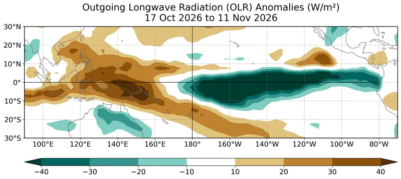
| October 2026 relative SSTs | Anomalies exceeded 4.0°C farther westward across the eastern equatorial Pacific. Niño indices: +2.5°C Niño-3.4, +3.6°C Niño-3, +4.4°C Niño-1+2. | Same discussion [source] |
| Subsurface, pentad of 4 November 2026 | Anomalies exceeding +10.0°C at depth in the eastern Pacific; deeper-than-average thermocline. | Same discussion, Figure 4 [source] |
| Historic-event chance | About 60% for a 3-month RONI of +2.5°C or more in October-December and November-January, remaining at better than even odds. Impacts not guaranteed. | Same discussion [source] |
| Next discussion | Scheduled for 10 December 2026. | Same discussion [source] |
| WMO, mid-August 2026 | El Niño firmly established. Nearly 100% probability of persisting through SON 2026 and DJF 2026–2027; further strengthening, very strong intensity, peaking towards the end of the year. Strength does not translate directly into the magnitude of impacts. | WMO update, page 3 September 2026 [source] |
| WMO NDJ forecast, 21 October 2026 | Ensemble-mean Niño 3.4 SST anomaly forecast approximately +3.8°C during NDJ 2026–27, peaking around December 2026. | WMO Global Seasonal Climate Update (opened with the August update) |
| CPC onset (FAQ) | Onset declared when the 3-month average SST departure exceeds 0.5 °C in the east-central equatorial Pacific (5°N–5°S, 170°W–120°W). | CPC ENSO FAQ [source] |
| Met Office guide | As a guide, episodes occur when Niño3.4 anomalies are larger than about 0.5 °C in magnitude for several months. Typical episode three or four seasons, peaking in boreal winter. | Met Office ENSO description [source] |
| Historical ONI | Threshold ±0.5 °C, 3-month running mean of ERSST.v6 SST anomalies in Niño 3.4, minimum of five consecutive overlapping seasons. No longer the official monitoring index. | ONI v6, and PIS 26-05 [source] |
| Official index now | Relative Oceanic Niño Index (RONI), per NWS Public Information Statement 26-05. Large RONI values do not necessarily correspond with the strength of the influence or expected impacts. | ONI v6 note and official RONI outlook [source] [source] |
| UK winter risk | El Niño increases the risk of a windy and mild start and a cold end to winter, moderated by competing drivers. La Niña increases the risk of a cold start and mild end. | Met Office climate drivers [source] |
| Global chances (Met Office) | El Niño: increased risks of floods in Peru and droughts in Indonesia, India and parts of Brazil; can push up global temperatures. La Niña: parts of Australia, Indonesia and equatorial South America typically wetter; southern USA often drought. El Niño thought to limit North Atlantic tropical storms; La Niña can enhance them. | Met Office climate drivers [source] |
Enjoyed a dated official advisory, unblended thresholds, and a careful look at chances rather than guarantees?
No pop-ups. No intrusive advertising. Just interesting stuff. A little support helps the next climates.im site get built.